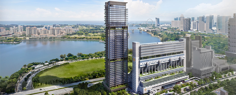
Aerial View of Golden Mile Singapore from Beach Road

Location
Immersed in a Buzzing Live-Work-Play Precinct

About Location

A Hub of Seamless Connectivity

Located within the Downtown Core, framed by the revitalisation of Beach Road and the Ophir-Rochor Corridor, Aurea also enjoys a prime location at the southern end of the North-South Corridor, offering easy access to key areas such as Orchard Road, the CBD and Marina Bay. Its strategic location near Kallang connects residents to a vibrant lifestyle hub, energised by the Kallang Alive Masterplan. The nearby Kallang Riverside Park and Kampong Glam offer nature, culture, and dining experiences.

The development offers proximity to Nicoll Highway, KPE and ECP, ensuring quick and convenient island-wide connectivity.

Sky Dining at The Dining Room Aurea
Aerial View of Golden Mile Singapore from Beach Road

Downtown Core Rejuvenation and Kallang Alive

Beach Road and Ophir-Rochor Corridor

Golden Mile Singapore - Aurea and The Golden Mile - joins a new generation of commercial and residential landmarks that are reshaping the downtown skyline. Immerse in the rich symphony of urban life within a dynamic mix of live-work-play experiences and heritage charm. Live close to amenities, from traditional eateries, hip cafes and shopping in Bugis and Kampong Glam, to sports and recreation in Kallang.

North-South Corridor

Expected to be completed in phases from 2027, this integrated transport corridor will provide enhanced connectivity to towns north of the city along with a network of dedicated cycling routes and walking paths.

Kallang Alive Masterplan

Situated in the heart of the 'Kallang Alive' Sports Hub area, Sport Singapore is introducing more sporting and community facilities such as The Kallang Football Hub, Kallang Tennis Hub and the upcoming Kallang Alive Loop. Additionally, the nearby conserved Old Kallang Airport is envisioned to feature a variety of lifestyle and recreational activities.

Neighourhood

MRT

Nicoll Highway MRT Station (Circle Line)
5 mins (walk)
Lavender MRT Station (East-West Line)
9 mins (walk)

Retail/ F&B

Golden Mile Food Centre
2 mins (walk)
North Bridge Road Market
6 mins (walk)
Kampong Glam Heritage District
9 mins (walk)
Raffles City
3 mins (drive)
Bugis Junction
3 mins (drive)
Suntec City
4 mins (drive)
Kallang Wave Mall
5 mins (drive)
The Shoppes at Marina Bay Sands
6 mins (drive)
Orchard Road Shopping Belt
8 mins (drive)

Leisure (Recreation, Parks, Nature, Entertainment)

Kallang Riverside Park
3 mins (walk)
Esplanade
5 mins (drive)
Sands Expo and Convention Centre
5 mins (drive)
Marina Bay
7 mins (drive)
Singapore Swimming Club
8 mins (drive)
Singapore Indoor Stadium & Future Indoor Arena (U/C)
9 mins (drive)
Singapore Sports Hub
9 mins (drive)
Gardens by the Bay
9 mins (drive)

Financial and Business Hubs

Business District - Bugis/Beach Road
2 mins (drive)
Central Business District
7 mins (drive)

Schools

HWA International School - MSQ Campus
3 mins (drive)
Nanyang Academy of Fine Arts (NAFA) - Bencoolen
3 mins (drive)
Invictus International School - Centrium Square Campus
4 mins (drive)
LASALLE College of the Arts - McNally Campus
4 mins (drive)
Singapore Management University (SMU)
4 mins (drive)
School of the Arts (SOTA)
5 mins (drive)
Farrer Park Primary School
6 mins (drive)
Hong Wen School (Primary)
6 mins (drive)
St Margeret's Primary
6 mins (drive)
Anglo-Chinese School (Junior)
7 mins (drive)
Kong Kwa School
7 mins (drive)
Dunman High School
8 mins (drive)
Future Singapore Sports School (Relocation to Kallang)
9 mins (drive)

Medical

Raffles Hospital
2 mins (drive)
Farrer Park Hospital
4 mins (drive)
Mount Elizabeth Hospital
11 mins (drive)
Singapore General Hospital
11 mins (drive)

Location Map

Explore Neighbourhood
    Downloads
    +65
    Submit
    Submit an enquiry to receive the latest updates on Aurea